
Sunday, November 17, 2013
Storms Shifting Southeast
Even though I think the line will weaken, here is what I think is possible over the next several hours. It may change, so I will have you updated.

Severe Storms Still Possible
Good evening,
It still looks like there might be severe storms in our area tonight. A strengthening line in Tennessee is now heading through the state of TN and may eventually reach Georgia and Alabama. I make today a Severe Weather Awareness Day, so all warnings/watches will be posted tonight. Main threats will be some wind, although a tornado cannot be completely ruled out in the extreme northwest corner of the state.
Mark
Friday, November 15, 2013
Next Major Cold Front
Good evening,
It has been quiet as of lately across Georgia. However, the next major system is shaping up in the West. This will be a fast moving cold front producing damaging winds and tornadoes on Sunday across the Lower Mississippi Valley and Ohio Valley. By late Sunday afternoon, the cold front will approach our coverage area, and there will be some storms especially in the northwest section of the state. The squall line will pass with some strong winds in the late evening through Northwest Georgia, and probably around 1 AM through the state's capital. It will continue to push through the state and weaken at the same time, becoming mainly a rain threat by Monday for southern Georgia and the coastal areas. I will post an update early Sunday, but meanwhile, here is my map for Sunday and Monday for Georgia.
Mark

Sunday, November 10, 2013
**MAJOR** Cold Blast Next Week
Good evening GA folks,
How was last winter? Disappointing, eh? Maybe a few flurries at your house? Comment what you got last winter below! Anyway, it does not look like this winter will be the same. It might be better. In fact, a huge Artcic block following a cold front and a weak system will arrive next week, and bring frigid air. This will very well bring the first snow of the season to the state of Georgia. All models are in good agreement of flurries in the Atlanta metro area to about an inch of accumulations in the higher elevations of Dawson, Union, Towns, Murray, White, Gordon, Gilmer, and Rabun counties. The precipitation will arrive Tuesday afternoon and stick through Tuesday night and possibly into Wednesday morning. Below is my precipitation type forecast for Tuesday into Wednesday.


How was last winter? Disappointing, eh? Maybe a few flurries at your house? Comment what you got last winter below! Anyway, it does not look like this winter will be the same. It might be better. In fact, a huge Artcic block following a cold front and a weak system will arrive next week, and bring frigid air. This will very well bring the first snow of the season to the state of Georgia. All models are in good agreement of flurries in the Atlanta metro area to about an inch of accumulations in the higher elevations of Dawson, Union, Towns, Murray, White, Gordon, Gilmer, and Rabun counties. The precipitation will arrive Tuesday afternoon and stick through Tuesday night and possibly into Wednesday morning. Below is my precipitation type forecast for Tuesday into Wednesday.

Also, here is my snowfall forecast for the same time period.

In addition, there might be slight travel problems north of I-20 Wednesday morning, as some ice may form slick spots on roads, especially bridges.
I will have an update tomorrow night and possibly again Tuesday afternoon.
Stay tuned!
Mark
Wednesday, November 6, 2013
Light Rain Tonight/Tomorrow
After a sunny week in Georgia, there is a chance of showers with a cold front tonight and tomorrow. Most of the heavier rain will be in the extreme northwest corner of Georgia. Here is a map explaining the rain chances tonight and tomorrow.


Thursday, October 31, 2013
Rain Timeline
The rain has begun for northern Georgia. Although severe weather is not likely, there will be winds with the rain. the rain will move through Atlanta starting 11 PM, and continue moving into Central Georgia overnight. Tomorrow, there will be damaging winds likely across Central and South Georgia with a squall line of severe storms forming. Also, a brief tornado or two might be possible embedded with the line. Also, for tonight, there might be a second round of storms coming in. There are some strong storms currently in Mississippi, and although these will probably weaken by the time they get here, there might still be gusty winds.
Wednesday, October 30, 2013
**Severe Weather HALLOWEEN EVENING**
Good afternoon,
It has come into my attention that the Storm Prediction Center has portions of Georgia in a severe weather risk are for both Day 2 (Halloween) and Day 3 (Friday). A strong cold front will be moving in with high wind shear, modest instability, and seasonal moisture. The dynamics are pretty good, so Georgia will see at least some severe weather with this system, consisting of at least isolated damaging winds. Although there is a tornado chance, it seems to be low currently. Below is the Storm Prediction Center's outlook for Halloween.


It has come into my attention that the Storm Prediction Center has portions of Georgia in a severe weather risk are for both Day 2 (Halloween) and Day 3 (Friday). A strong cold front will be moving in with high wind shear, modest instability, and seasonal moisture. The dynamics are pretty good, so Georgia will see at least some severe weather with this system, consisting of at least isolated damaging winds. Although there is a tornado chance, it seems to be low currently. Below is the Storm Prediction Center's outlook for Halloween.

As you can see, most of the action will be to our west during the day. Places like Memphis, Tennessee, Paducah, Kentucky, and Cincinnati, Ohio, will see damaging winds and isolated tornadoes somewhere in the area. However, by evening, around 8-9 PM, the pre-frontal zone of activity will begin approaching Georgia, and after 9 or 10 PM, there could be a threat for some damaging wind gusts in northern and western Georgia. Also, if there will be any tornadoes with this front, tomorrow evening in North Georgia might be the only time when they might happen. Nevertheless, I doubt that there will be enough rotating storms or rotation within them to produce anything more than just damaging winds. Still, if you live in areas to the north of I-20 and to the west of I-85, you might want to change your outdoor Halloween plans to indoors. And if your kid does decide to go trick-or-treating, they must definitely go inside if they hear thunder. Below is the Storm Prediction Center's outlook for Friday.

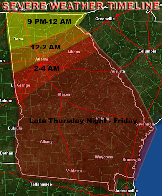
Again, a lot of the state of Georgia will be in a risk area for severe storms. A lot of this might be late during the night, between 2 and 6 AM, but during daytime, additional storms will fire up in central and southern Georgia. Although the line will be a lot weaker, the marginal threat for damaging winds will still exist, although the tornado threat will be near zero. Below is my preliminary timeline for the severe storms tomorrow night into Friday.

Thank you for tuning in. An update will be posted tomorrow afternoon.
Mark
Subscribe to:
Posts (Atom)