Thursday, October 31, 2013
Rain Timeline
The rain has begun for northern Georgia. Although severe weather is not likely, there will be winds with the rain. the rain will move through Atlanta starting 11 PM, and continue moving into Central Georgia overnight. Tomorrow, there will be damaging winds likely across Central and South Georgia with a squall line of severe storms forming. Also, a brief tornado or two might be possible embedded with the line. Also, for tonight, there might be a second round of storms coming in. There are some strong storms currently in Mississippi, and although these will probably weaken by the time they get here, there might still be gusty winds.
Wednesday, October 30, 2013
**Severe Weather HALLOWEEN EVENING**
Good afternoon,
It has come into my attention that the Storm Prediction Center has portions of Georgia in a severe weather risk are for both Day 2 (Halloween) and Day 3 (Friday). A strong cold front will be moving in with high wind shear, modest instability, and seasonal moisture. The dynamics are pretty good, so Georgia will see at least some severe weather with this system, consisting of at least isolated damaging winds. Although there is a tornado chance, it seems to be low currently. Below is the Storm Prediction Center's outlook for Halloween.


It has come into my attention that the Storm Prediction Center has portions of Georgia in a severe weather risk are for both Day 2 (Halloween) and Day 3 (Friday). A strong cold front will be moving in with high wind shear, modest instability, and seasonal moisture. The dynamics are pretty good, so Georgia will see at least some severe weather with this system, consisting of at least isolated damaging winds. Although there is a tornado chance, it seems to be low currently. Below is the Storm Prediction Center's outlook for Halloween.

As you can see, most of the action will be to our west during the day. Places like Memphis, Tennessee, Paducah, Kentucky, and Cincinnati, Ohio, will see damaging winds and isolated tornadoes somewhere in the area. However, by evening, around 8-9 PM, the pre-frontal zone of activity will begin approaching Georgia, and after 9 or 10 PM, there could be a threat for some damaging wind gusts in northern and western Georgia. Also, if there will be any tornadoes with this front, tomorrow evening in North Georgia might be the only time when they might happen. Nevertheless, I doubt that there will be enough rotating storms or rotation within them to produce anything more than just damaging winds. Still, if you live in areas to the north of I-20 and to the west of I-85, you might want to change your outdoor Halloween plans to indoors. And if your kid does decide to go trick-or-treating, they must definitely go inside if they hear thunder. Below is the Storm Prediction Center's outlook for Friday.

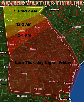
Again, a lot of the state of Georgia will be in a risk area for severe storms. A lot of this might be late during the night, between 2 and 6 AM, but during daytime, additional storms will fire up in central and southern Georgia. Although the line will be a lot weaker, the marginal threat for damaging winds will still exist, although the tornado threat will be near zero. Below is my preliminary timeline for the severe storms tomorrow night into Friday.

Thank you for tuning in. An update will be posted tomorrow afternoon.
Mark
Wednesday, October 23, 2013
Cold Blast Forecast
Good afternoon,
Many of you in the state of Georgia were probably experiencing windy and chilly conditions all morning. The wind seems to be subsiding a bit finally.
A Frost Advisory will be in effect tonight for a good chunk of Georgia.

Temperatures will range from the upper 30s across Central Georgia to the upper 20s in the high elevations of North-Central and Northeast Georgia. You need to take indoors or cover all plants, as well as take pets indoors. If the necessary precautions are not taken, damage to plants and animals might happen. Here is a link to the full warning text by the National Weather Service in Peachtree City, Georgia: http://forecast.weather.gov/showsigwx.php?warnzone=GAZ033&warncounty=GAC121&firewxzone=GAZ033&local_place1=&product1=Frost+Advisory#.Umgw2vlJ6So
Here is my forecast for tonight's lows.

Just in case, if anyone is wondering, there will be NO snow with this system anywhere in Georgia. At best, there will be a few sprinkles tomorrow evening, but even that is almost out of the picture.
The second part of the cold blast will occur on Friday, so an update will be out tomorrow evening or Friday morning.
Mark
Quick Update
It is now very windy and pretty chilly across much of Georgia. The cold blast has started. There are frost advisories in effect for a big portion of North and Central Georgia. A more detailed update with maps will come out in the next few hours.
Thursday, October 17, 2013
Next Week's Frost/Freeze Forecast
Here is the preliminary forecast map that I created regarding next week's cold blast. Please note that the map is partially based on elevations as well as model data.


Showers Today & Possible Cold Snap Next Week
Good afternoon,
After a week of very quiet weather across Georgia, today we are experiencing some showers across the state. This activity will continue to transition into the central and southern portions of the state through the afternoon and evening, leaving cloudy skies in north Georgia.
Tomorrow, there will still be showers and isolated thunderstorms, with the main threat being lightning, across south Georgia. After that, a new wave of activity will move into Georgia on Saturday, bringing drizzle and showers across central and southern Georgia. Although the ECMWF model shows drizzle in north Georgia too, it will probably be limited to the central and southern portions of the state.
Finally, more showers will reach Georgia next week, around Tuesday, but it is too early to outline what exactly will be going on.
In addition, there is another big matter on the clock that is shaping up for the end of next week. Preliminary model runs suggest a massive cold front to push through on Tuesday/Wednesday, bringing a huge cold blast for Thursday/Friday. All mountains above 3000 feet in northern Georgia will have a chance to get below freezing during the night. Areas as far as the Atlanta metro area will be experiencing a frost during the night. Please be aware that this could damage plants, so make sure you cover your plants if this trend continues.
Daytime temperatures might not get out of the 50s across the Atlanta metro area and even portions of the Piedmont, and will likely remain in the 40s at elevations above 3000 feet. Some places above 4500 feet could actually not get higher than 43 degrees. While this is still preliminary, you should be aware of this, and stay tuned to Georgia Weather Plus for updates on this situation.
I will have a preliminary map out this evening, and another update next week.
Stay tuned!
Mark
Friday, October 11, 2013
Pleasant Fall Weather
So far, fall has finally settled in for real. We have these strings of days that have fall-like weather cross the state of Georgia. It is sunny day after day now, and will continue to be so through the weekend and early next week. This is the kind of weather, which would fit your outdoor plans, or maybe just resting out there in the sun! High pressure is very deep here (around 1019 millibars) and that is the reason for the sunny dry weather.
However, a front will finally arrive late next week and possibly into next weekend, producing showers and possibly a few storms. This is far out, so I am not really worried about it just yet.
A summary map regarding the high pressure for the weekend and the front by late next week will be posted tonight or tomorrow.
Mark
Sunday, October 6, 2013
Severe Weather This Evening
Good afternoon,
A few days ago, I mentioned that Tropical Storm Karen will impact Georgia. Well, since then, it dissipated, and left only a strong cold front that will be coming through Georgia this evening. Areas along and west of I-85 will have a chance to see small hail, gusty winds, brief minor flash flooding, and a few isolated tornadoes. Most of the activity will be between 7 PM and 1 AM. The enhanced threat for severe storms will be in Walker, Chatooga, and Dade Counties in extreme northwest Georgia, and that will be between 7 and 10 PM.
I classify today as a Severe Weather Awareness Day, so all severe weather (severe thunderstorm and tornado) warnings will be posted.
Stay tuned!
Mark
Thursday, October 3, 2013
Tropical Storm Karen
Tropical Storm Karen has formed in the Southern Gulf of Mexico east of the Yucatan Peninsula! It is expected to reach hurricane strength and landfall anywhere from New Orleans to Pensacola. This hurricane will weaken as it will head inland, but it will impact Georgia during late Sunday into Monday. Rainfall could be possible from 1 inch to as much as 4 inches. In addition, wind gusts of 30 - 45 MPH accompanied by weak tornadoes will be likely. Now is the time to prepare for this system and get your emergency plans ready.
I will have an outlook or several outlooks out tomorrow or Saturday for this system. It is too early now, because the track may still change. Here is the National Hurricane Center's graphic about Tropical Storm Karen.

I will have an outlook or several outlooks out tomorrow or Saturday for this system. It is too early now, because the track may still change. Here is the National Hurricane Center's graphic about Tropical Storm Karen.

Subscribe to:
Comments (Atom)